|
| |
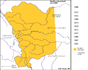
Changes
to Blackfeet Reservation Through the 19th Century
Click on a date to the right of the map to see the extent of the
Blackfeet Reservation at that time. The reservations, as shown in
1895, are virtually unchanged today. |
| |
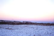 Badger
Valley at twilight
Badger
Valley at twilight, Ghost Ridge in the distance.
S. Thompson photo |
| |
| Treaty 7 |
| | |
| |
|
| |
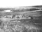 Siksika
camp at Blackfoot Crossing, ca.1900.
The signing of Treaty
7 occurred at "Blackfoot Crossing" on
the Bow River, which is located on the Siksika Reserve east
of Calgary, Alberta.
Image courtesy of Glenbow
Archives.
NA-1094-4
|
| |
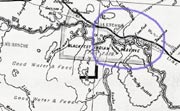
Portion
of 1888 Dominion of Canada map, showing the section of the Bow River
with Blackfoot Crossing marked.
Courtesy of the Glenbow Museum Archives.
|
|
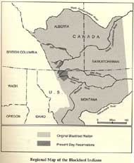
Regional map of
Blackfoot homelands with present day reservations.
(Samek, 1987).
|
|
|
Great Falls > Culture > The Shrinking Reservation
|
Life continued on, much as it always had, for Blackfeet
people for the first years after the Lame Bull Treaty
of 1855. One difference
was the addition of an agent, based at Fort Benton,
who was assigned to distribute annuities promised by
the treaty. The annuities were
not always sent, and after years of trade in buffalo
robes, this mainstay was less predictable. People starved
in 1861, the year
the Mullan Road carried newcomers along the old trail
between Fort Benton and Fort Walla Walla. |
| Ā |
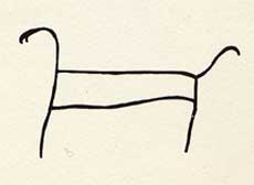 (Raczka: 1979)
|
1861 - When they eat dogs.
Again, starvation times. |
|
| Ā |
| Then with the Gold Rush of 1862, the traditional Blackfeet world
began to fall apart. Within a few short years, more than 15,000
miners were working and exploring in and around Blackfeet country.
Some traditional hunting grounds were overrun by miners and diseases,
for which the people had no resistance. Scarlet fever killed more
than 1,000 Blackfeet in 1864. |
| Ā |
| 1865 Treaty |
| Ā |
| In 1865 a small group of tribal leaders agreed to sell their lands
south of the Missouri River to the U.S. government. They sold 2,000
square miles of land for $1 million. The new treaty was never ratified,
but with the assent of the Indians, the Executive
Order of 1873 set apart a reserve for the joint occupancy
of the Gros Ventres, Piegan, Bloods, Blackfeet, and River Crows.
This new Great Northern Reservation, defined by an Act
of Congress in 1874, was in part composed of territory
assigned the Blackfeet by the Treaty of 1855. It did not, however,
comprise all of that territory, for the U.S. government moved the
southern boundary of the reservation 200 miles northward, opening
lands to settlement without any compensation to the tribe. |
| Ā |
| Massacre of the Small Robes, 1870 |
| Ā |
| As pressures grew, so did intertribal conflicts, especially
with the Cree and Assiniboine and with the rapidly growing numbers
of settlers. Some bands tried to avoid trouble, yet the young
men were hard to control during these difficult times. One of
the most peaceful bands was the Small Robes, led by Chief Heavy
Runner. |
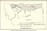
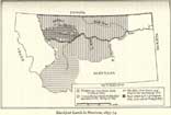 Blackfoot lands in Montana, 1855-74.
Ewers, 1958. |
On a cold January morning of 1870, with much suffering
in the lodges because of smallpox,Chief Heavy Runner's
camp was attacked by U.S. troops. A total
of 173 Indians (many of whom were women and children)
were killed in retaliation for the killing of a white
man
by some
young
Piegans.
Some
2,000 Blackfeet died of smallpox
that winter. |
| Ā |
| The Last Buffalo |
| Ā |
The last buffalo hunt took place in 1882, south of the Sweet
Grass Hills. What
Isaac Stevens had predicted¢the extinction
of the buffalo¢had come true. The Blackfeet became completely
dependent on government annuities for their survival.
Thousands of hungry people moved to the agency on Badger
Creek, yet rations were not available. People starved.
The winter that followed is still known among the people
as "starvation winter." Hundreds of Piegans died. The
ridge behind the agency is still known as "Ghost Ridge"
because so many people were buried there that year.
Since the time of the first treaty, 80 percent of the
Piegans had died, and the buffalo were gone. Life would
never be the same.
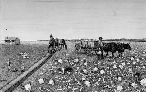
"The End", 1913.
Martin S. Garretson.
Courtesy of National Museum
of Wildlife Art.
|
| Ā |
| Act of Congress, 1887 |
| Ā |
| With growing numbers of settlers surrounding the shrinking reservation,
the U.S. government responded to pressure from white ranchers by
negotiating another land treaty with the tribes of the region.
These land
cession hearings were held in the dead of winter, when
many Blackfeet could not attend. A bare majority of Blackfeet leaders
passed an agreement to split the Great Northern Reservation into
three separate agencies and to relinquish all but 45 square miles.
In exchange for $125,000 per year for 10 years, the Blackfeet ceded
17 million acres of their homeland. |
| Ā |
| Act of Congress, 1895 |
| Ā |
One final land cession of the 19th century, the
"ceded
strip," reduced the reservation by another 800,000
acres along the "Backbone of the World." For
the Blackfeet this land was like their church. The mountains
held
gifts from
the Creator, provided for their long-term health and
well-being. Many plants, animals, minerals, and pure
water used in their customary
practices are found there, and the high peaks allow
seekers to reach toward Creator Sun while staying connected
to Mother Earth.
White Calf, the Piegan chief, told the treaty commissioners
how he felt about the loss of these mountain lands and
his other concerns
for his people:
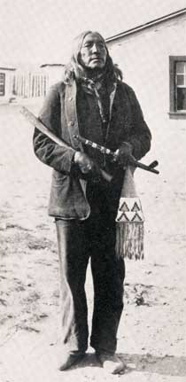 White Calf
Image courtesy of Montana Historical Society. |
"Chief Mountain is my head. Now my head is cut
off. The mountains have been my last refuge. We have
been driven here and now we are settled. From Birch
Creek to the boundary is what I now give you. I want
the timber because in the future my children will need
it....The right to hunt...the grazing land...to fish
in the mountains...we will sell you the mountain portion
of our land....We don’t want our Great Father
to ask for anything more. We will have to send you away.
We don’t want our lands allotted....There
are many little children going to school and getting
an education; there is no end to civilizing our children.
They are the ones that will get the benefits from these
lands" (White Calf in U.S. Senate doc. 118: 1896, from
Sept. 1895 proceedings).
Ā
Ā
|
| The Blackfeet sold this land, now Glacier Park
and part of the Lewis and Clark Forest, for $1.5 million with
the agreement (codified in Article 5) that tribal lands would
not be subjected to allotments. |
Blackfoot Lands in
Montana, 1875-Present.
Ewers, 1958. |
|
| Ā |
| 1912 Allotment of Lands |
| Ā |
"The opening of reservation
lands to settlement was legislated without the
tribe's consent, as per the General Allotment
Act. Each enrolled member of the Blackfeet tribe
was granted an allotment of land within the
reservation. Any lands not accounted for within
this allocation were opened for sale to the
public. A survey of the reservation identified
just over 1.5 million acres, which would be
allocated to some 2,500 Blackfeet, leaving nearly
800,000 acres to be opened for settlement" (Samek:
1987).
Often without Blackfeet participation or agreement, this tribe
lost approximately half its land base, much of it without
compensation.
|
| Ā |
Background: Portion
of 1892 Rand McNally Montana map,
courtesy of Malcolm MacCalman |
|
|
|
